A Guide to Earth Satellite Orbits: From LEO to GEO and Beyond
Explore how different satellite orbits, from low Earth orbit to Lagrange points, support global communications, navigation, observation, and deep-space research.
Space has become an essential domain of modern life, powering everything from global communications and navigation to weather forecasting and defense. What was once the realm of a few dozen government satellites has rapidly evolved into a densely populated orbital environment. In 2013, approximately 1,000 satellites orbited Earth; by the end of 2024, that number had surged past 11,500, reflecting the accelerating pace of commercial and governmental investment in space-based infrastructure.
Although the space beyond Earth’s atmosphere is vast, most human‑made satellites operate within three main orbital regimes: low Earth orbit (LEO), medium Earth orbit (MEO), and geostationary Earth orbit (GEO). Each orbit offers unique advantages and challenges, shaping how satellites are used for communication, navigation, observation, and research.
Low Earth Orbit
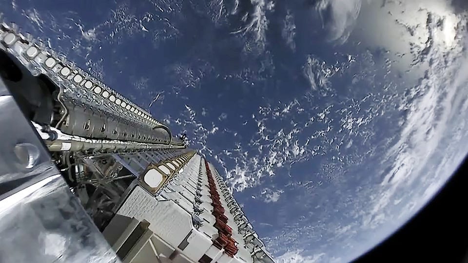
Satellites in low Earth orbit (LEO) travel at altitudes ranging from 200 to 2,000 kilometers. Because of their proximity to Earth, they travel at high speeds, usually completing a full orbit in 1.5–2 hours.
This low altitude makes LEO satellites ideal for:
Earth observation (such as climate monitoring and mapping)
Reconnaissance
Communication services
Signal Transmission Time
The close proximity to Earth allows LEO satellites to transmit and receive data with significantly lower latency, making them well-suited for real-time activities such as streaming, online gaming, and video calls, tasks that are often challenging or unfeasible with higher‑altitude satellites. Compared to GEO satellites, LEO satellites are roughly 15 to 70 times faster.
Affordability and Scalability
Beyond performance benefits, the rapid growth of satellites in low Earth orbit is also driven by cost and scalability. Many LEO satellites are built using commercial off-the-shelf components, making them significantly cheaper and faster to produce and launch than their higher-orbit counterparts. Most are designed for shorter operational lifespans, enabling regular upgrades with newer technologies.
A key enabler of this expansion has been the sharp reduction in launch costs. In 1981, sending one kilogram of payload to the LEO could cost over $65,000 (e.g., using the Space Shuttle). By 2019, with the introduction of partially reusable rockets such as SpaceX’s Falcon Heavy, that cost fell to under $1,500 per kilogram.
This combination of accessibility and affordability has lowered barriers to entry, accelerated innovation, and fueled the growth of a new commercial space economy. As a result, LEO has become the most densely populated orbital regime, currently hosting approximately 80% of all operational satellites.
Human Space Activity
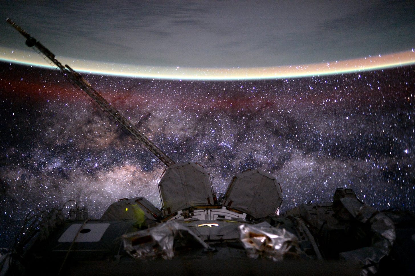
Nearly all crewed space activity takes place in LEO, including the International Space Station (ISS), which orbits at an altitude of about 400 km. With the exception of the Apollo missions, humans have not ventured beyond this orbit.
Inclination and Polar Orbits
Orbital inclination refers to the angle between a satellite’s orbital plane and Earth’s equator. It determines how far north or south the satellite travels during its orbit.
An inclination of 0° means the satellite orbits directly above the equator.
An inclination of 90° means the satellite travels over Earth’s poles (geographic, not magnetic), in what is called a polar orbit.
An inclination of 180° indicates a retrograde equatorial orbit, moving opposite to Earth’s rotation.
Different inclinations serve different purposes. For example, low-inclination orbits are often used for communications satellites serving equatorial regions, while high-inclination orbits are used for Earth observation and scientific missions that require global coverage.
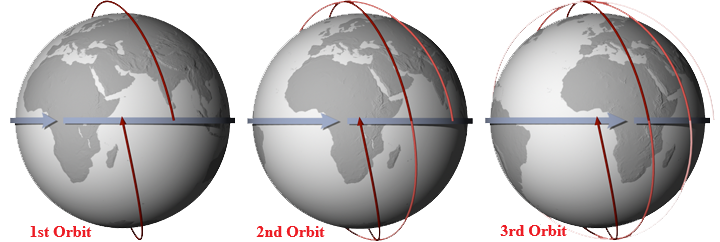
Satellites in polar orbits (an inclination of 90°) pass over or near both poles on each revolution. Due to Earth’s rotation beneath them, these satellites cover different vertical swaths of the planet with each pass. As a result, a single LEO polar‑orbiting satellite can observe nearly every point on Earth’s surface twice per day.
However, launching into a high-inclination orbit requires more energy than launching into a low-inclination or equatorial orbit. This is because equatorial orbits can harness Earth’s rotational speed to gain an extra boost, whereas polar launches must work against this natural assist. This is why rockets are typically launched eastward from near-equatorial sites, taking full advantage of the planet’s spin to conserve fuel and reach orbits more efficiently.
Constellations
To achieve continuous global coverage, some operators deploy satellites as part of large “constellations”, networks of dozens, hundreds, or even thousands working together. This architecture offers high fault tolerance: if one satellite fails, others in the network can seamlessly take over its function, ensuring minimal disruption. For example:
The Iridium constellation consists of 66 satellites, along with additional backups, orbiting at about 780 km, and enabling worldwide satellite phone communication.
SpaceX’s Starlink is a constellation of more than 7,500 satellites (accounting for over 60% of all operational spacecraft) orbiting at an altitude of about 550 kilometers. While technically capable of providing global coverage, access remains restricted in certain countries, such as China and Russia, due to regulatory and political barriers. Some evidence also suggests that, access may be intentionally limited or even disabled due to political or strategic considerations.
Medium Earth Orbit
Between LEO and GEO lies the medium Earth orbit (MEO), typically ranging from 2,000 to 35,786 kilometers in altitude.
Satellites in MEO benefit from:
Larger footprints (viewing more of Earth’s surface at once than LEO satellites)
Shorter signal delays than GEO satellites
The Global Positioning System
The most famous MEO constellation is the Global Positioning System (GPS), consisting of 24 active satellites orbiting at about 20,200 km and circling the Earth twice a day. This setup ensures that any point on Earth can connect with at least four GPS satellites at any given time.
Highly Elliptical Orbits
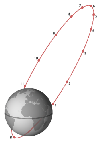
Some MEO satellites follow highly elliptical orbits (HEO), which allow them to spend extended time over one hemisphere.
A notable example is the Molniya orbit. The satellite accelerates as it approaches Earth (perigee) and decelerates near its highest point (apogee), allowing it to linger over one hemisphere for about two-thirds of each orbit, which has a 12-hour period. Since both the United States and Russia are located in the northern hemisphere, Molniya orbits were particularly well-suited for reconnaissance missions during the Cold War.
Geostationary Earth Orbit
At an altitude of 35,786 kilometers, satellites in geostationary Earth orbit (GEO) take exactly 24 hours to complete a revolution, matching Earth’s rotation. From this distance, each GEO satellite can observe roughly one-third of Earth’s surface.
Satellites directly above Earth’s equator with no inclination are called geostationary. This makes them appear stationary relative to the planet’s surface, allowing continuous coverage of specific regions. They are widely used for:
Communications
Broadcasting
Weather monitoring
Though not as crowded as LEO, GEO is the second most populated orbit used today.
Limitations of GEO Satellites
Despite their advantage in providing continuous coverage, GEO satellites face several key limitations.
Because of their distance from Earth, GEO satellites experience significantly longer communication delays:
LEO signals: ~0.003 seconds per round‑trip
GEO signals: ~0.25 seconds per round‑trip
This added latency requires echo control and timing adjustments that are far more negligible for lower-altitude orbits.
In addition, launching and maintaining GEO satellites is costly. Reaching geosynchronous orbit (GEO is a specific type of it) requires significantly more energy, resulting in higher launch costs per kilogram of payload. Until recently, GEO satellites were also non-serviceable once deployed, limiting flexibility for repair or upgrades.
Other Notable Orbits
Sun‑Synchronous Orbit
A sun-synchronous orbit (SSO) is a specialized type of polar orbit, designed so that a satellite passes over the same regions of Earth at approximately the same local solar time on each orbit. This creates consistent lighting conditions, enabling sun-synchronous satellites to capture images with uniform shadow angles and illumination, critical for Earth observation tasks such as climate tracking, vegetation analysis, and disaster monitoring, where comparing data over time is essential.
Lagrange Points
Lagrange points are special orbits in space where the combined gravitational pull of the Earth and the Sun balances with a satellite’s orbital motion, allowing it to remain fixed relative to both bodies.
Of the five such points in the Earth–Sun system, two (L4 and L5) are gravitationally stable and require no continuous propulsion to maintain position, making them especially suitable for extended space operations and long-term missions.
Others, like the second Lagrange point (L2), are ideal for scientific observation. Positioned directly behind Earth relative to the Sun, L2 allows satellites to use a single heat shield to block both solar and terrestrial radiation, creating a thermally stable environment for sensitive instruments. This makes the L2 a preferred location for space telescopes.
Dangers of Space
The Van Allen Radiation Belts
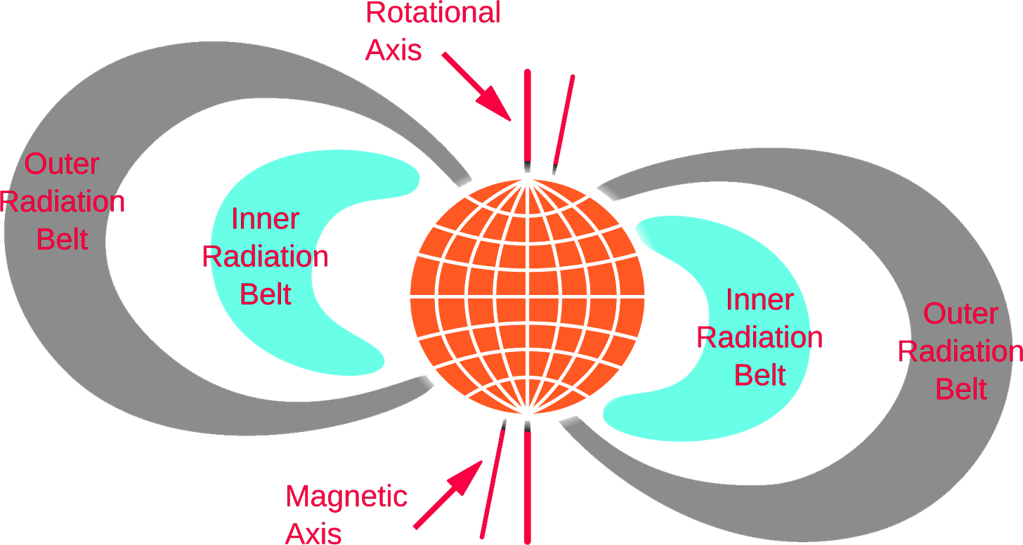
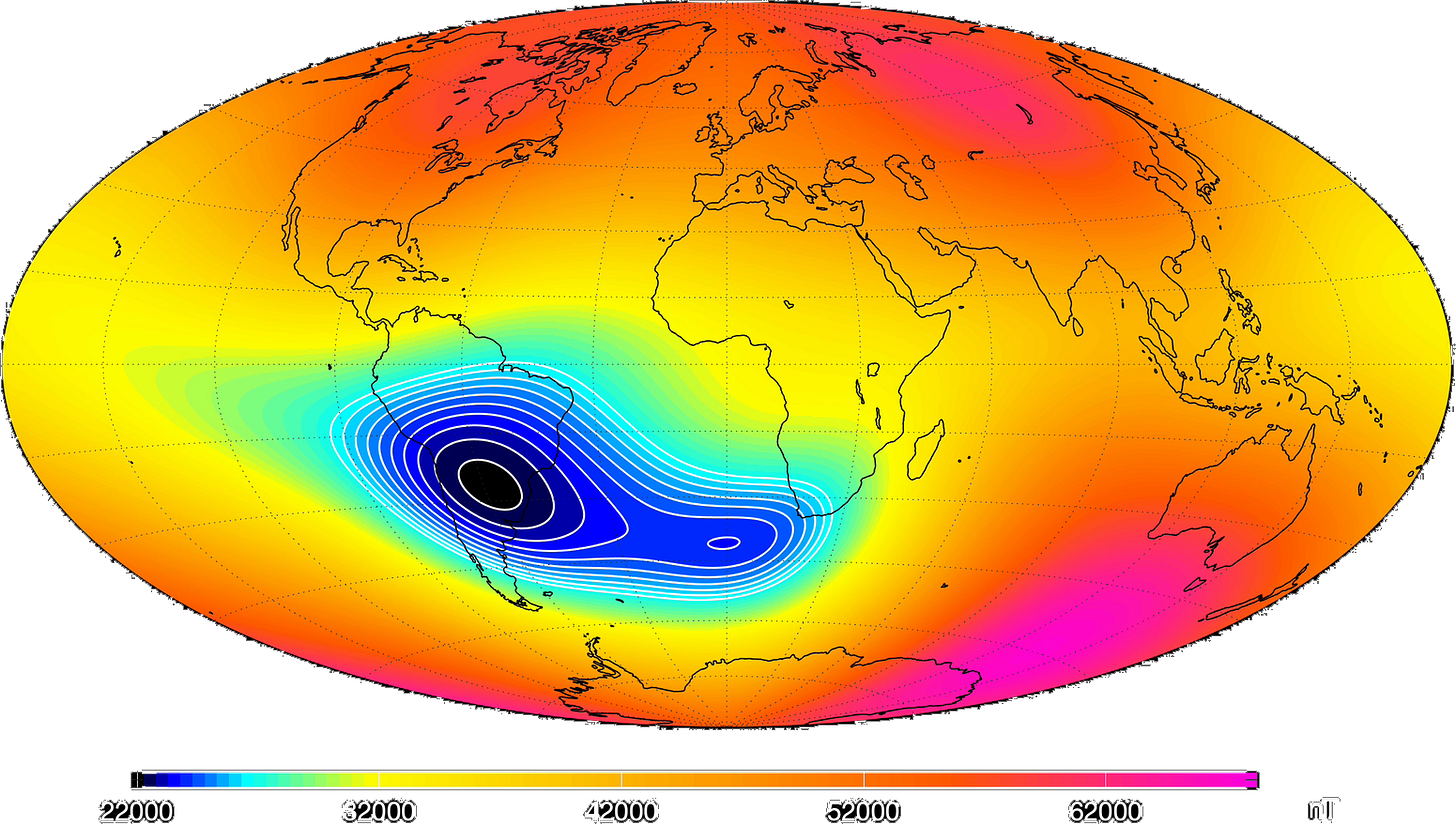
Earth is surrounded by radiation belts, also known as the Van Allen belts: doughnut-shaped zones of high-energy particles trapped by the planet’s magnetic field. These particles generate intense ionizing radiation that can damage electronics, degrade solar panels, and pose risks to humans in orbit.
There are two main belts:
Inner belt: Roughly from 300 to 10,000 km
Outer belt: Roughly from 10,000 to 40,000 km
The structure and intensity of the belts are highly dynamic, especially in response to solar activity. Solar storms can cause the belts to expand, occasionally reaching down to the orbit of the ISS and below, and sometimes even form a temporary third belt.
To withstand the harsh conditions in these regions, spacecraft operating within or passing through the belts must be equipped with radiation shielding and other protective measures to limit long-term exposure and ensure continued functionality.
Space Debris
As Earth’s orbits, particularly LEO, become increasingly crowded, space junk has emerged as a growing threat. This debris includes defunct satellites, spent rocket stages, and thousands of fragments from past collisions or explosions caused by leftover fuel or structural degradation. Even tiny pieces, traveling at high velocities, can inflict significant damage on impact.
LEO is especially vulnerable due to the sheer number of satellites operating in a relatively narrow band and the high speeds required to counter Earth’s stronger gravitational pull at lower altitudes.
To reduce this risk, mission control teams now routinely monitor orbital debris and perform avoidance maneuvers when necessary. While collisions remain rare, the risk of cascading impacts (Kessler Syndrome) is rising, prompting urgent calls for improved space traffic management, greater situational awareness, and international cooperation to ensure the long-term sustainability of space operations.
Conclusion
Satellites operate in a variety of orbits, each offering specific advantages and trade-offs depending on the mission. These orbital paths are selected based on factors such as coverage, latency, cost, and observational needs. For example, low Earth orbit is favored for Earth imaging and communication constellations, while geostationary orbit enables constant coverage of fixed regions. Highly elliptical orbits and special positions like the Lagrange points further expand the possibilities for scientific observation and future space infrastructure. Understanding these orbital strategies is essential for grasping how satellites support communication, navigation, weather forecasting, and space exploration.
References
Baker, Harry. 2025. How Many Satellites Could Fit in Earth Orbit? And How Many Do We Really Need? LiveScience. May 30.
BIRA-IASB. n.d. Radiation Belts: Energetic Particles Encircling Earth. Belgian Institute for Space Aeronomy. Accessed August 7, 2025.
BlueCosmo. n.d. Iridium Satellite Network. Accessed August 6, 2025.
ESA. n.d. About space debris The European Space Agency. Accessed August 8, 2025.
ESA. n.d. What are Lagrange points? The European Space Agency. Accessed August 7, 2025.
Howell, Elizabeth. 2018. Van Allen Radiation Belts: Facts & Findings. Space.com. May 12.
Kuthunur, Sharmila. 2025. Russia and China are threatening SpaceX's Starlink satellite constellation, new report finds. Space.com. April 8.
Manning, Catherine G. 2023. What is GPS? National Aeronautics and Space Administration. September 25.
NASA. 2013. NASA’s Van Allen Probes Reveal a New Radiation Belt around Earth. National Aeronautics and Space Administration. June 6.
NASA. 2025. NASA CubeSat Finds New Radiation Belts After May 2024 Solar Storm. National Aeronautics and Space Administration. February 6.
NASA. n.d. Lagrangian Points. National Aeronautics and Space Administration. Accessed August 7, 2025.
NASA. n.d. The Rotating Earth. National Aeronautics and Space Administration. Accessed August 8, 2025.
NASA. n.d. What is space radiation?. National Aeronautics and Space Administration. Accessed August 7, 2025.
Our World in Data. n.d. Cost of Space Launches to Low Earth Orbit. Accessed August 6, 2025.
ReliaSat. 2024. Satellite Communications Evolution - From GEO to LEO. January 26.
Riebeek, Holli. 2009. Catalog of Earth Satellite Orbits. National Aeronautics and Space Administration. September 4.
Roberts, Thomas G. 2022. Popular Orbits 101. Center for Strategic & International Studies. June 14.
Roberts, Thomas G. 2022. Space Launch to Low Earth Orbit: How Much Does It Cost?. Center for Strategic & International Studies. September 1.
Roulette, Joey, Cassell Bryan-Low, and Tom Balmforth. 2025. Musk ordered shutdown of Starlink satellite service as Ukraine retook territory from Russia. Reuters. July 27.
SIA. 2025. SIA Spectrum Report. Satellite Industry Association. January.
SpaceMath. n.d. The Deadly Van Allen Belts? National Aeronautics and Space Administration. Accessed August 7, 2025.
SpaceX. n.d. Falcon Heavy. Accessed August 6, 2025.
Wainscott-Sargent, Anne. 2025. The Changing Risk Landscape in LEO vs GEO: Differences Impact Service, Response, Mitigation and Sustainability. May 22.
Wall, Mike. 2022. Kessler Syndrome and the space debris problem. Space.com. July 14.


